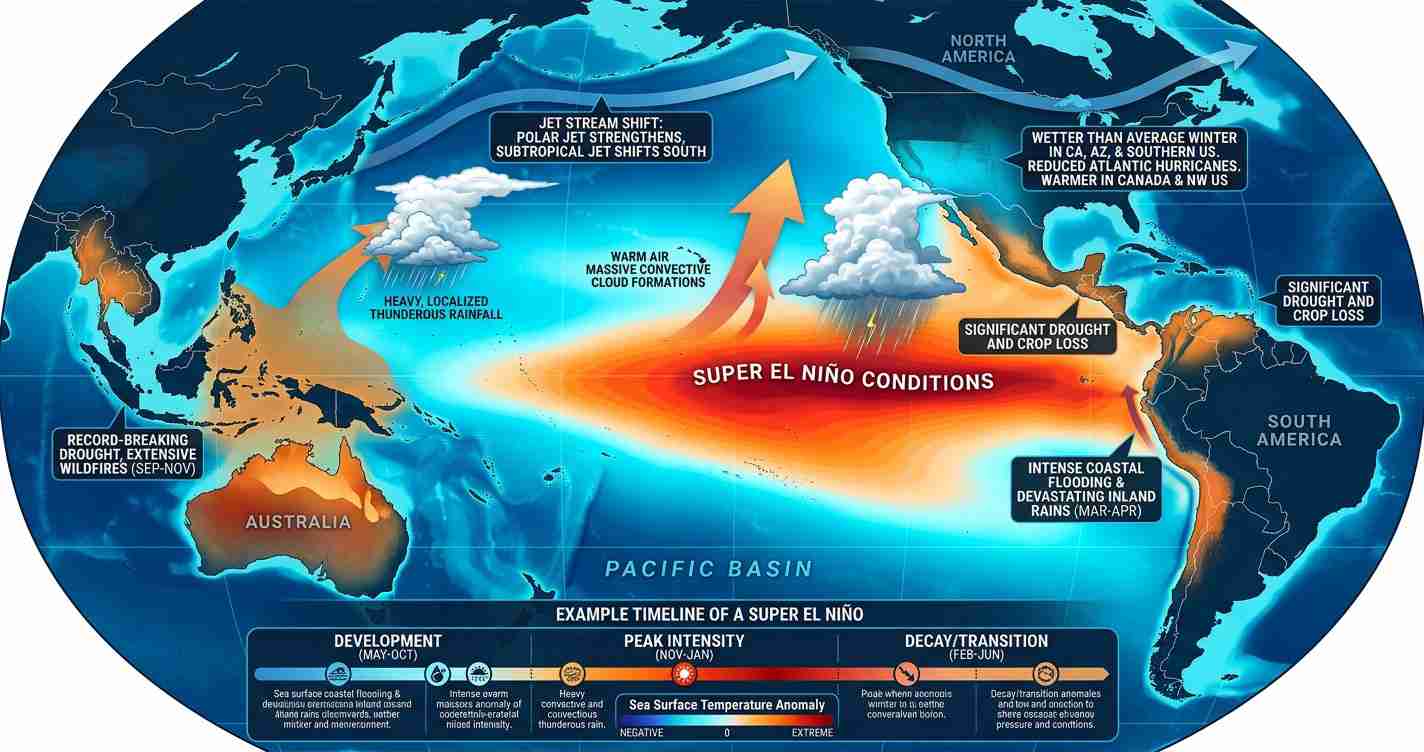
El Niño Could Ignite the 2026 Eastern Pacific Hurricane Season — What That Means for the U.S. Southwest and Utah
Lede: A predicted El Niño could drive a more active 2026 Eastern Pacific hurricane season by warming sea surface temperatures and reducing wind shear, raising odds of more storms and stronger hurricanes with impacts for Mexico, the U.S. Southwest and Utah.
Key takeaways
- El Niño likely boosts Pacific activity: Models give about a 61% chance of El Niño by May–July 2026 and ~25% chance it becomes a Super El Niño by fall, increasing odds of more named storms, hurricanes and major hurricanes (Fox Weather; Time).
- Mechanisms matter: Warmer sea surface temperatures and reduced local wind shear in the Eastern Pacific favor storm formation and rapid intensification (see YouTube analysis, YouTube analysis).
- Utah impacts are indirect but real: Remnants and moisture plumes can produce heavy rain, flash floods and debris flows in southern Utah; wetter winters could also affect water supply (sources: Fox Weather; Time).
How El Niño works in the East Pacific
El Niño is a natural climate pattern that warms parts of the central and eastern tropical Pacific Ocean. That warming alters regional winds and atmospheric circulation, which in turn changes storm behavior worldwide.
In the Atlantic basin, El Niño often increases upper-level winds that inhibit hurricane formation. In the Eastern Pacific the effect can be the opposite: warmer sea surface temperatures (SSTs) and reduced local wind shear often help thunderstorms organize and intensify into tropical cyclones (Fox Weather; YouTube analyses).
Why El Niño can “ignite” the Eastern Pacific season
1) Warm sea surface temperatures (SSTs)
Current Pacific SSTs are running 1–3°C above average in parts of the basin. Those warm waters serve as fuel for tropical systems. Recent Pacific cyclones have mixed heat into deeper layers, raising ocean heat content that future storms can tap (YouTube analysis; Fox Weather; Time).
2) Reduced wind shear locally
While El Niño often raises vertical wind shear over the Atlantic (suppressing storms there), the Eastern Pacific frequently sees lower shear. Lower shear helps thunderstorms align over a storm’s center, promoting organization and strengthening (YouTube analysis; Wikipedia).
3) Higher ocean heat content and rapid intensification
Deep warm water can supply the energy for rapid intensification. Hurricane Otis (2023) is a stark example: it exploded from a tropical storm to a catastrophic hurricane in about a day — a process tied to very warm, deep water under the storm (Fox Weather).
Quote: “Warm ocean heat content and reduced shear can enable rapid intensification” — operational analyses and media reporting.
Timing: why early El Niño matters
The Eastern Pacific hurricane season runs May 15–November 30, 2026 (Central Pacific June 1–November 30) and typically peaks July–October. If El Niño becomes established before mid-summer, the basin could be in a favorable state early in the peak months, increasing the chance of a busier season. Late-season development (after August) may shift early-season activity toward the Atlantic and Gulf before Pacific conditions fully change (Wikipedia; YouTube).
Forecast outlook and what a Super El Niño would mean
NOAA and many climate models placed roughly a 61% chance of El Niño forming in May–July 2026, with some model clusters assigning roughly a 25% chance it could intensify into a Super El Niño by fall. A stronger event would likely push Pacific anomalies higher — possibly into the 2–3°C range in key regions — and yield an Eastern Pacific season more active than a standard El Niño year (Time; Fox Weather; Wikipedia).
Historical context and numbers
On average, moderate-to-strong El Niño years in the Eastern Pacific have produced about 17 named storms, 9 hurricanes and 5 major hurricanes — slightly above the basin norm (roughly 15 named storms, 8 hurricanes and 4 major hurricanes). Observational studies show that about 85% of moderate-or-strong El Niño events since 1990 linked to elevated Eastern Pacific activity (Fox Weather; YouTube analyses).
Operational outlook for the 2026 Pacific hurricane season
Forecast groups released early outlooks in April 2026 pointing to a likely above-average Eastern Pacific season. Forecasters urged early-season watches and improved planning because early El Niño development could fast-track an active season (Wikipedia; Fox Weather).
Implications for Utah
Direct hurricane strikes are unlikely — Utah is well inland — but the state can still feel effects when remnants or moisture plumes travel north into the U.S. Southwest. Expect risks of heavy rain, flash flooding and mountain runoff that can impact communities and infrastructure (Fox Weather; Time).
- Flood and debris-flow risk: Remnants and enhanced monsoon flows can drop intense rainfall on steep terrain. Burn scars are especially vulnerable — local emergency managers should review evacuation routes and debris-flow plans now.
- Water supply: A stronger El Niño often favors wetter winters in parts of the U.S. Southwest, which could boost Utah’s snowpack and reservoirs if seasonal patterns align; water managers and farmers should monitor forecasts closely (Time).
- Infrastructure and preparedness: City planners and road crews should inspect storm drains, culverts and bridge clearances; rural counties managing low-water crossings should check emergency gear.
- Economic and insurance concerns: A busier Eastern Pacific season could increase claims in Mexico and Baja, stress supply chains and affect tourism linked to Utah’s outdoor economy.
- Cross-border coordination: Major impacts in Mexico could require federal and state coordination; Utah officials should be ready to work with FEMA regional offices and neighboring-state emergency teams.
Practical steps for Utah residents and leaders
- Stay informed: follow NOAA, the National Hurricane Center and local weather offices for watches and warnings; consult media coverage and official advisories (Fox Weather).
- Review emergency plans: local governments should check evacuation routes, communication plans and debris-flow protocols now.
- Inspect infrastructure: clear culverts and check drainage near highways and low-lying roads.
- Prepare property: homeowners in flood-prone areas should consider sandbags, cleared gutters and appropriate insurance coverage.
- Manage water resources: farmers and water managers should track forecasts to time reservoir releases and irrigation plans.
Reporting notes and sources
This article synthesizes forecasting guidance and analyses from media and forecasting outlets and several expert videos. Key references include Fox Weather, Time, the 2026 Pacific hurricane season context on Wikipedia, and several expert videos (YouTube; YouTube; YouTube).
For operational forecasts and watches, monitor NOAA, the National Hurricane Center and your local weather offices.